
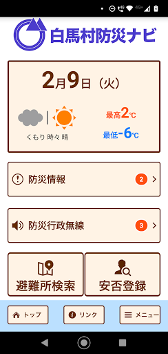
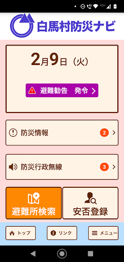
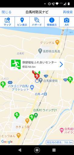
Features 白馬村防災ナビ
"Hakuba Village Disaster Prevention Navi" is the official app of Hakuba Village.Designated evacuation shelters and designated emergency evacuation shelters around your current location and details are displayed, and the AR camera function and evacuation compass function support evacuation behavior in the event of a disaster.In addition, hazard maps such as sediment-related disaster warning areas, flood inundation areas, and tsunami inundation areas are also displayed, so you can check the danger of your current location.In addition, we will notify you of various disaster prevention information such as evacuation information and weather warnings by push notification."Hakuba Village Disaster Prevention Navi" can be used not only in Hakuba Village but all over the country, and the map display can be used even when offline.[Main functions]・ Automatic search for designated evacuation shelters and designated emergency evacuation shelters around your current location・ Hazard map display of sediment-related disaster warning areas, inundation areas, etc.・ Display of disaster prevention information and danger information at your current location・ AR camera function, evacuation compass function・ Offline function・ Push notification of disaster prevention information, list display・ Safety registration, safety confirmation
Gaming Features
Enjoy immersive gaming experience with various game modes.
Camera Features
Advanced camera features with editing capabilities.
Weather Features
Get accurate weather forecasts and real-time updates.
See the 白馬村防災ナビ in Action
Get the App Today
Available for Android 8.0 and above